 hotel5 km

Wild south · Saint-Philippe
Pointe de la Table: camping on the 1986 lava flow from Piton de la Fournaise
A wild site in the south-east, a volcanic landscape shaped by the 1986 eruption. Black lava, filao trees (casuarinas) that have taken root, a deep blue ocean. Free camping with no facilities at all.
Pointe de la Table, south-eastlocation1986 lava flow and casuarinastypeCar and a 15-minute walkaccessFreecost
Pointe de la Table, on the south-east coast of Reunion Island between Saint-Philippe and Le Tremblet, still bears the marks of the 1986 eruption of Piton de la Fournaise. The lava flow reached the ocean right here, forming a striking black volcanic landscape that filaos and pandanus have since partly recolonised. Camping here means sleeping right on a page of recent geological history.
This page covers everything you need to know before pitching a tent: access from the N2, gear suited to a wild site with no facilities, safety on the lava, hikes starting from the trail, and nearby activities to combine it with (lava tunnel, Route des Laves, helicopter). If you'd rather not sleep in a tent, a campervan can stay parked at the car park, a 15-minute walk from the site.
At a glance
The essentials for camping at Pointe de la Table
The experience
A night on the 1986 lava flows
Arrival. From the car park, follow the marked trail across the black flows for about 15 minutes. The ground is uneven and sharp in places, so closed shoes are essential. As you near the sea, vegetation takes back over, and clusters of filaos and pandanus create shaded spots to pitch a tent.
The setting. The contrast is striking: the black of the 1986 flows in the foreground, the green of the filaos that have taken root over 40 years, the blue of the ocean stretching to the horizon. When the sea is rough, waves surge up through the basalt cracks in white geysers, similar to Pointe au Sel but rawer.
The old crater. The trail also climbs up to the 1986 crater, a short distance from the camping spot. It's one of the rare chances in Reunion Island to see one of Fournaise's secondary craters from the ground, no helicopter required.
Night. With no light pollution, the starry sky is outstanding when the clouds clear, and the waves breaking on the flows keep up a constant backdrop. Insect repellent comes in handy early in the evening.

The setting
Filaos and pandanus on the lava
Filaos (casuarina trees) were among the first species to recolonise the 1986 flow. Their powerful roots push through the lava and stabilise the ground, while pandanus (vacoas) fill in along the shoreline to form the coastal vegetation typical of the wild south.
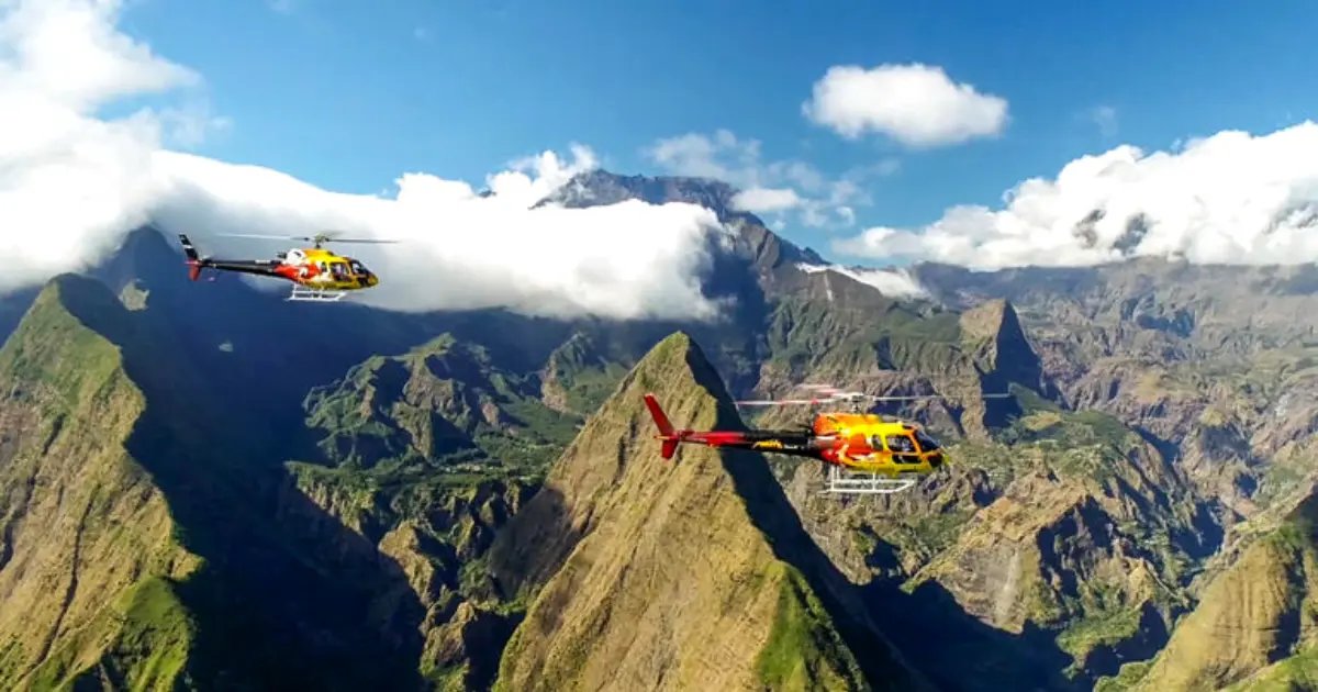
The whole area is even more striking seen from the sky. From above, you can make out the full extent of the 1986 flow, the 2007 flow further south at Pointe du Tremblet, and the active crater of Piton de la Fournaise beyond.
Route
How to get to Pointe de la Table
From Saint-Philippe, take the N2 heading east for about 6 kilometres until you see a “Pointe de la Table” sign on your right. Park on the left.
The 15-minute trail crosses the 1986 flows until it reaches the seafront filao groves. No vehicles are allowed on the flows. Fill up with fuel and buy supplies in Saint-Philippe town centre, 15 minutes away.
Backpack
What to pack for the night
- A wind-resistant tent: the south-east coast faces the trade winds constantly
- A sleeping bag rated to 12°C: nights by the sea stay mild
- Rain gear: showers are possible year-round in the wild south
- Closed shoes with a grippy sole: the 1986 lava is sharp in places
- A head torch: there's no lighting and it gets pitch dark
- At least 2L of water per person: no water point on site
- A portable gas stove: no fires allowed on the flows
- Bin bags: take everything back out with you, as the site is wild and fragile
Read before you go
A wild site: watch out for the lava and the sea
Pointe de la Table is a wild site with no facilities and no supervision. Come fully self-sufficient for water, food, toilets and first aid. No fires are allowed on the flows: there's a fire risk to the filaos and an ecological risk to the pioneer vegetation.
The basalt edges of the 1986 flow are sharp in places: keep closed shoes on at all times, and watch children closely. The sea is dangerous: there's no beach, waves crash on the rocks, and currents are strong. Swimming isn't possible. Stay well back from the edge when there's a swell.
To combine
Activities to do in the wild south

Piton de la Fournaise Lava Tunnel
Caving exploration through the volcano's lava flows, 15 minutes to the north.
See the activity

Rafting on the Rivière des Marsouins
A raft descent of the east coast's main river, departing from Saint-Benoît, 1 hour away.
See the activity

Bélouve and Trou de Fer Hike
A guided trail to the viewpoint over the island's tallest waterfall, in the hills above Salazie.
See the activity
 Also worth combining
Aerial view
Piton de la Fournaise and the Recent Lava Flows, Seen from the Sky
Camping here puts you at ground level with the 1986 flow. A helicopter flight opens up the bigger picture: it flies over the active Piton de la Fournaise, its craters, and every historic lava flow that has reached the sea since the 1980s, including the 1986 one you're camping on.
8 routes departing from Saint-Pierre or Saint-Paul, from 15 minutes to 1 hour.
From €125 · 210 Manawa reviews · Saint-Pierre / Saint-Paul
See helicopter prices
Other spots
Other wild south camping spots
Puits Arabe, Saint-Philippe
A neighbouring spot on the south coast, equipped with toilets and a BBQ area, 5 minutes by car.
See the spot
Puits des Français, Cap Méchant
A seafront spot in the wild south, on the basalt flows.
See the spot
Ti Sable Beach, Saint-Joseph
Wild camping on a black sand beach in the wild south, 30 minutes to the west.
See the spot
Sleep nearby
Accommodation near Pointe de la Table
Places to stay within 25km, in the wild south and surrounding areas.
hotel5 km hotel9 km
 auberge10 km
Frequently asked questions
FAQ: camping at Pointe de la Table
How do you get to Pointe de la Table?
From Saint-Philippe, take the N2 heading east for about 6km until you see a "Pointe de la Table" sign on your right. Park on the left, then allow around 15 minutes on foot to reach the site. The trail crosses the 1986 lava flow.
Is camping free here?
Yes, camping at Pointe de la Table is free and open to all, in the casuarina and pandanus areas set back from the shore. There's no booking and no fee. There's no equipment on site, so full self-sufficiency is required.
Why camp on lava flows?
Pointe de la Table still bears the marks of Piton de la Fournaise's 1986 eruption, when the lava flow reached the ocean right here. The contrast between the solidified black lava, the green of the filaos (casuarina trees) that have since taken root, and the blue of the ocean makes it an outstanding setting for a night out in raw volcanic nature.
Are there any facilities on site?
No, there aren't really any facilities at Pointe de la Table: no toilets, no water point, no built fire pits. It's a wild site that calls for full self-sufficiency. For facilities, head to Puits Arabe instead, 5 minutes away by car.
Can you light a fire on the lava?
No, no fires are allowed on the flows. A portable gas stove is the only option for cooking. Don't walk barefoot on the lava, as its basalt edges can cut. Never stub out a cigarette on the ground either, even a small burn mark stays visible for years.
What hikes start from the site?
A 2-hour loop from the car park takes in Puits Arabe, the 1986 crater and several coastal viewpoints. Heading north, a trail leads to Pointe du Tremblet and the "youngest beach in the world", formed by the 2007 lava flows.
What activities go well with camping here?
The wild south sits right at the gates of Piton de la Fournaise: lava tunnel exploration, the Route des Laves, the Bélouve / Trou de Fer hike in the hills above Salazie, or a helicopter flight to observe the volcano's active crater.
Page last updated on 20 October 2026. GPS coordinates and access details verified as of this date.